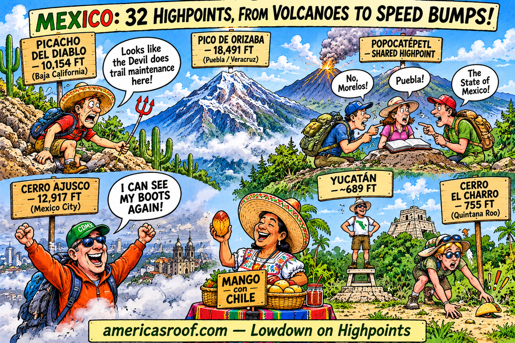
The highest point in all of Mexico is Pico de Orizaba (Citlaltépetl) at 5,636 meters (18,491 feet) above sea level, located on the border between the states of Puebla and Veracruz. [1, 2]
Mexico is divided into 32 federal entities (31 states and Mexico City). Below is the highest point (state highpoint) for each of these entities according to geographic and INEGI data: [1]
Highpoints by State and Mexico City
| State / Federal Entity | Highest Point (Peak or Area) | Elevation (approx.) |
|---|---|---|
| Aguascalientes | Cerro de la Ardilla | 3,050 m (10,006 ft) |
| Baja California | Picacho del Diablo (Sierra de San Pedro Mártir) | 3,095 m (10,154 ft) |
| Baja California Sur | Sierra de la Laguna | 2,080 m (6,824 ft) |
| Campeche | Cerro Champerico | 380 m (1,247 ft) |
| Chiapas | Volcán Tacaná (shared with Guatemala) | 4,067 m (13,343 ft) |
| Chihuahua | Cerro Mohinora | 3,308 m (10,853 ft) |
| Coahuila | Cerro San Rafael | 3,715 m (12,188 ft) |
| Colima | Volcán de Colima (Volcán de Fuego) | 3,830 m (12,566 ft) |
| Durango | Cerro Gordo | 3,357 m (11,014 ft) |
| Guanajuato | Sierra Los Agustinos | 3,110 m (10,203 ft) |
| Guerrero | Cerro Tiotepec | 3,533 m (11,591 ft) |
| Hidalgo | Cerro La Peñuela | 3,380 m (11,089 ft) |
| Jalisco | Nevado de Colima (Tzapotépetl) | 4,270 m (14,009 ft) |
| Estado de México | Popocatépetl (shared border with Puebla/Morelos) / Nevado de Toluca | 5,413 m / 4,690 m |
| Michoacán | Volcán Tancítaro | 3,840 m (12,598 ft) |
| Morelos | Popocatépetl (shared border) | 5,413 m (17,759 ft) |
| Nayarit | Cerro El Vigía (Cerro del Faro) | 2,760 m (9,055 ft) |
| Nuevo León | Cerro El Potosí | 3,720 m (12,205 ft) |
| Oaxaca | Cerro Nube (Quie Yelaag / Cerro el Nacimiento) | 3,720 m (12,172 ft) |
| Puebla | Pico de Orizaba (Citlaltépetl) | 5,636 m (18,491 ft) |
| Querétaro | Cerro El Zamorano | 3,340 m (10,958 ft) |
| Quintana Roo | Cerro El Charro | 230 m (755 ft) |
| San Luis Potosí | Cerro Grande | 3,180 m (10,433 ft) |
| Sinaloa | Cerro Alto | 2,800 m (9,186 ft) |
| Sonora | Cerro Pico Guacamayas | 2,620 m (8,596 ft) |
| Tabasco | Sierra Tapijulapa | 900 m (2,953 ft) |
| Tamaulipas | Peña Nevada | 3,510 m (11,516 ft) |
| Tlaxcala | La Malinche (Matlalcueye) | 4,430 m (14,534 ft) |
| Veracruz | Pico de Orizaba (Citlaltépetl) | 5,636 m (18,491 ft) |
| Yucatán | Cerrito Benito Juárez (Punzó / Ticul area highpoint) | ~210 m (689 ft) |
| Zacatecas | Cerro Los Pelones | 3,160 m (10,367 ft) |
| Mexico City (CDMX) | Cerro Ajusco | 3,937 m (12,917 ft) |
Key Geographical Notes
- Volcanic Core: Most of the country’s highest points are concentrated along the Trans-Mexican Volcanic Belt (Eje Neovolcánico), which runs east-west across central Mexico. [1, 2]
- Shared Peaks: Major stratovolcanoes like Popocatépetl and Iztaccíhuatl span state boundaries (serving as the high point for multiple states simultaneously, including Puebla, State of Mexico, and Morelos). [1, 2]
- Lowland Exceptions: Only a few states in the flat lowlands and peninsulas (such as Yucatán, Campeche, and Quintana Roo) have high points under 500 meters. [1]
Humorous Overview
Here are some jokes about Mexico’s state highpoints, from the towering volcanoes to the flat peninsulas:
The Lowland Lowdowns
- Yucatán’s highpoint is basically a speed bump. Hikers there don’t need oxygen tanks; they just need to stand on a sturdy stepstool.
- A tourist went to Quintana Roo to bag the state highpoint. They accidentally stepped over Cerro El Charro while looking for a dropped taco.
- If you trip and fall while hiking to the high point of Yucatán, don’t worry. You won’t tumble down a ravine; you’ll just roll into a nice hammock.
Volcano Identity Crises
- Pico de Orizaba is the subject of a major boundary dispute. Puebla and Veracruz have been sharing the peak for centuries, and neither one wants to carry the summit register back down the mountain.
- Popocatépetl is the ultimate shared highpoint roommate. It serves as the roof for Morelos, Puebla, and the State of Mexico, and it expresses its feelings about property lines by occasionally throwing up ash.
- In Mexico City, you don’t climb Ajusco to get closer to the gods. You climb it just to get above the smog line so you can see your own boots.
Highpoint Hiker Realities
- Baja California’s Picacho del Diablo translates to “Devil’s Peak.” It earned that name because after navigating the cactus, the heat, and the loose rocks, you’re pretty sure the Devil himself is running the trail maintenance crew.
- A climber boasted about bagging the highpoint of Aguascalientes (Cerro de la Ardilla). When they got to the top, a squirrel was already there, charging a toll and refusing to share its acorns.
- What’s the difference between highpointing in the US and in Mexico? In the US, you celebrate a summit with an energy bar. In Mexico, you celebrate a summit by finding out there’s already a guy at the top selling fresh mango with chili powder.