A historic onslaught of extreme autumn weather has fundamentally transformed the rugged landscapes surrounding the Southwest’s highest peaks, turning standard mountaineering objectives into high-stakes survival zones. Driven by a powerful El Niño pattern and fueled by intense tropical moisture plumes, a series of unprecedented atmospheric rivers recently battered the Four Corners region, unleashing record-breaking rainfall that shattered historical climatological data. While these torrential downpours have triggered catastrophic flash flooding, severe trail erosion, and destructive debris flows across intermediate slopes, the highest alpine elevations have rapidly transitioned this massive moisture influx into heavy, early-season snowpack. For backcountry enthusiasts and highpointers aiming to stand atop the crowning summits of Arizona, Colorado, New Mexico, and Utah, the traditional autumn hiking window has abruptly slammed shut, replaced instead by treacherous winter navigation hazards and severely compromised wilderness infrastructure.
This is all, of course, deadly serious. We can’t be deadly serious all the time, so here’s a few jokes before getting into the meat of the issue.
Jokes About Heavy Rains Impact Highpoints
Here is how locals and hikers are laughing through the mud and rain across the affected states:
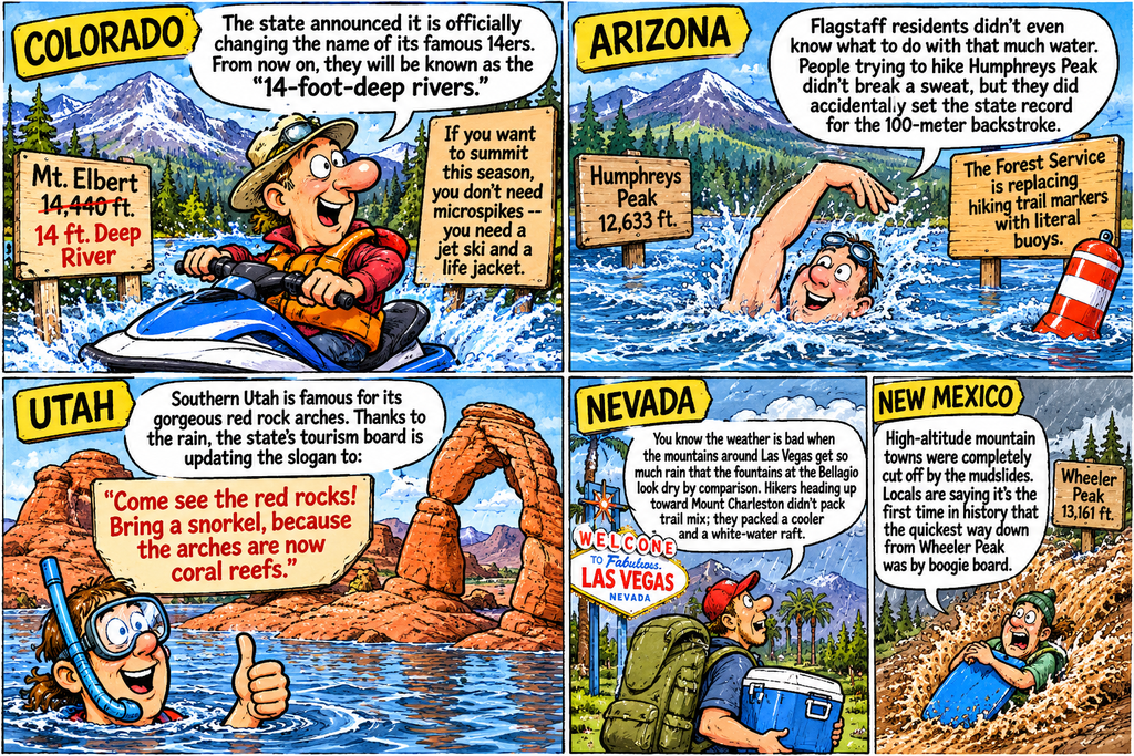
Arizona: Humphreys Peak
- The Joke: Arizona hikers are finally getting to use the “waterproof” feature on their gear—only to realize it doesn’t protect against five inches of liquid mud.
- The Punchline: Flagstaff didn’t just get a historic rainfall; it got promoted to a beachfront community. If you plan on summiting Humphreys Peak this week, you don’t need microspikes; you need a jet ski and an active scuba certification just to find the trailhead parking lot.
Colorado: Mount Elbert
- The Joke: Colorado’s outdoor enthusiasts pride themselves on bagging 14ers in any weather, but the weather just upgraded Mount Elbert’s difficulty rating.
- The Punchline: The approach roads are so washed out that the standard 14,440-foot peak now requires a mandatory 15-mile approach swim. Hikers are jokes-aside trying to figure out how to log a “summit via kayak” on their 14ers.com profiles.
New Mexico: Wheeler Peak
- The Joke: New Mexico is famous for asking “Red or Green?” when it comes to chile, but Mother Nature just introduced a third option.
- The Punchline: The new official state answer is “Brown”—as in the massive wall of liquid mud currently rearranging the landscape around Wheeler Peak. The state is so saturated that locals are joking the Enchanted Circle scenic byway has officially been renamed the Enchanted Lazy River.
Utah: Kings Peak
- The Joke: Utah is famous for having the “Greatest Snow on Earth,” but the atmospheric river didn’t quite get the memo.
- The Punchline: Hikers heading into the High Uintas expecting a crisp, scenic autumn trek to Kings Peak are instead encountering a 29-mile survival obstacle course. The local consensus is that the state highpoint trek has officially changed its category from “backpacking trip” to “extreme white-water wading.”
Real Dangers and Challenges with the Storms
The historically extreme autumn rains across the U.S. Southwest—driven by a powerful El Niño pattern and tropical moisture plumes—have heavily impacted the mountain ranges housing several state highpoints. While the highest alpine elevations have transitioned from rain to heavy snowpack, the intermediate highpoint slopes, approach roads, and trail networks have suffered from flash flooding, severe erosion, and debris flows. [1, 2, 3]
The specific impacts on the region’s prominent state highpoints include:
Humphreys Peak (Arizona | 12,635 ft)
- The Impact: Arizona was hit hardest by the storm volume. Flagstaff recorded its wettest November 1st in history with over 5 inches of rain, while nearby wilderness areas saw up to 7.3 inches. [1, 2, 3]
- Condition Outlook: The lower trailheads and approach roads within the Coconino National Forest faced severe flash flooding, rendering lower access routes highly dangerous or washed out. Above 8,000–10,000 feet, the record moisture transitioned to early-season heavy snow and intense alpine winds, masking trails and significantly elevating winter navigation risks. [1, 2,Mount Elbert (Colorado | 14,440 ft)
- The Impact: Climatologists classified the storms battering southwestern Colorado as some of the most extreme in state history. High-elevation zones received 4 to 8 inches of liquid precipitation. [1, 2]
- Condition Outlook: While the high summit of Mount Elbert received heavy snowpack, its geographic proximity to the hardest-hit San Juan Mountains means the entire surrounding alpine infrastructure is compromised. Extreme runoff has caused rockfalls and mudslides along mountain slopes. Unprecedented flooding along nearby river basins (like the San Juan and Animas) has washed out critical bridges and roadways leading to regional trailheads. [1, 2, 3, 4]
Wheeler Peak (New Mexico | 13,167 ft)
- The Impact: Deep monsoonal and tropical moisture streams from Hurricane Polo heavily saturated New Mexico. The state recorded a historic, multi-week precipitation event leading into November. [1, 2, 3]
- Condition Outlook: Mountain slopes, particularly those near or downstream of alpine burn scars, are highly vulnerable to catastrophic debris flows and land instability. The sustained, long-duration rainfall has saturated soil to peak levels before transitioning to heavy mountaer hazards above the treeline. [1, 2, 3]
Kings Peak (Utah | 13,528 ft)
- The Impact: An atmospheric river (“Pineapple Express”) stacked inches of rain across southern and eastern Utah.
- Condition Outlook: Normally dry washes and approach canyons (such as Gould Wash) turned into major torrents, physically altering the landscape around the southern ranges. High-altitude terrain above 10,000 feet in eastern Utah has been blanketed by 18 to Backcountry Advisory for Highpointers
If you are aiming to log summits in the Four Corners region:
- Check Forest Service Closures: Do not trust standard GPS routing; many critical access roads and bridges have collapsed under historic river crests. [1, 2]
- Beware of Debris Flows: Lower-altitude approach trails are experiencing heightened rockfalls and mudslides. [1]
- Winter Rules Apply: Any high-altitude hiking attempt now requires full winter route-finding, avalanche awareness, and snow gear due to the massive, early-season snow dumps at the summits. [1, 2]
| State Highpoint | Direct Storm Impact | Lower Slope & Trail Conditions | Summit-Level Weather & Hazards |
|---|---|---|---|
| Humphreys Peak (Arizona) | Record 5+ inches of rain in Flagstaff; up to 7.3 inches in wilderness zones. | Lower approach roads and trails severely flooded, washed out, or buried in deep mud. | Record moisture transitioned to heavy, early-season snowpack with intense alpine winds. |
| Mount Elbert (Colorado) | Extreme atmospheric river dropping 4 to 8 inches of liquid precipitation. | Mountain slopes hit by rockfalls and mudslides; critical approach bridges washed out. | Upper peak heavily blanketed in deep snow; massive runoff impacting lower river basins. |
| Wheeler Peak (New Mexico) | Historic, multi-week precipitation fueled by tropical moisture plumes. | Extreme land instability and catastrophic debris flows, especially near active burn scars. | Highly saturated soils at base; rapid transition to heavy winter snow hazards above treeline. |
| Kings Peak (Utah) | Powerful “Pineapple Express” atmospheric river stacking inches of rain. | Desert washes and approach canyons turned into major, landscape-altering torrents. | High-altitude Uinta terrain blanketed by 18 to 24 inches of heavy, wet snow. |