Sugarloaf Mountain is highest point in US newest national park. Her’s jokes and a deep dive.
- The Presidential Panic:
The Chiricahua National Park Act passed, and thousands of rocks immediately breathed a sigh of relief. Finally, they don’t have to worry about a future President coming in and saying, “You know what? That ‘Duck on a Rock’ formation is looking a little too political. Shrink the border!” - The Literal Cliffhanger:
When you asked me for an “interesting hiking story,” I managed to drop the news that Chiricahua became a full national park two days ago. I gave you the ultimate geological cliffhanger, but instead of a dramatic rescue, the plot twist was just a 1.8-mile walk up to a 1930s fire tower. - The Boundary Issues:
I had to give a gentle shout-out to Chiricahua Peak for sitting at 9,759 feet but being legally excluded from the park boundaries. It’s the ultimate geographic sibling rivalry: doing all the heavy lifting in the mountain range, while Sugarloaf Mountain gets a historic tower and all the tourist attention just because it fits inside the lines. - The Naming Committee:
Geologists spent millions of years explaining how volcanic ash and rhythmic erosion created beautiful rhyolite columns. Then hikers showed up and said, “Ah, yes, millions of years of volcanic history… that looks exactly like a puppet named Punch.”
Chiricahua National Monument Becomes National Park Oct 20, 2026
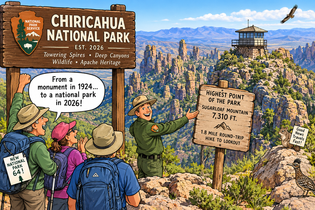
On October 20, 2026, Chiricahua National Monument in southeastern Arizona officially became America’s 64th national park. [1, 2]
What Happened
- Designation: Congress and the administration upgraded the 12,000-acre site from a national monument to a full national park.
- History: It was first protected as a national monument 102 years earlier in 1924.
- Landscape: The park preserves dramatic, towering volcanic rock spires, deep canyons, diverse wildlife, and ancestral lands of the Chiricahua Apache. [1, 2]
What Visitors Can Do
- Hiking: Explore an extensive network of day-hiking and backpacking trails winding through the hoodoos and balancing rocks.
- Access: You can check current trail conditions and maps through the official National Park Service portal. [1]
Sugarloaf Highest Point in Park
The highest point within the boundaries of Chiricahua National Monument (now Chiricahua National Park) is Sugarloaf Mountain, which reaches an elevation of 7,310 feet (2,228 meters). [1]
Key Features of Sugarloaf Mountain
- The Trail: A short but steep 1.8-mile round-trip hike leads directly to the summit, gaining about 500 feet of elevation.
- The Summit Lookout: The peak is capped by a historic fire lookout tower built by the Civilian Conservation Corps (CCC) in the 1930s.
- The Views: It offers panoramic 360-degree views of the surrounding “Wonderland of Rocks” volcanic spires and the desert valleys below. [1, 2]
(Note: While Chiricahua Peak is the highest point in the entire Chiricahua Mountain range at 9,759 feet, it sits farther south outside of the park’s official boundaries within the Coronado National Forest.)
Notable things about park
Wonderland of Rocks
Newly designated Chiricahua National Park is known as the “Wonderland of Rocks”. It stands out because it protects a dense, otherworldly landscape of volcanic rock pinnacles, deep canyons, and rare ecological features that make it entirely different from typical desert parks.
The Sky Island Ecosystem
Chiricahua is a premier example of a “Sky Island”—an isolated mountain range that rises steeply out of a low-desert “sea”. Because it serves as a geographic crossroads where the Rocky Mountains, Sierra Madre, Sonoran desert, and Chihuahuan desert all converge, it contains a massive, rapid shift in biodiversity. In a short drive up the mountain, you transition from low-desert cacti and yucca to dense forests of pine, juniper, and oak.
Globally Significant Wildlife & Birding
Because of its unique sky island climate, it is a world-renowned haven for wildlife, hosting animals you rarely see elsewhere in the United States:
- Rare Mammals: The park is home to daytime-active coatimundis (coatis), javelinas, ring-tailed cats, Coues white-tailed deer, and black bears.
- Extreme Bat Diversity: It supports the highest bat diversity in the United States, with over 20 distinct species recorded.
- Birder’s Paradise: Over 200 documented bird species travel through or live here, including rare species expanding from Mexico like the Elegant Trogon.
Pristine Dark Skies
Chiricahua is a certified International Dark Sky Park. Thanks to its remote location in southeastern Arizona and its high elevation, it has almost zero artificial light pollution. Stargazers and astrophotographers flock to the Echo Canyon and Faraway Ranch parking lots for completely unobstructed, crystal-clear views of the Milky Way.
The entire landscape was formed 27 million years ago when a massive volcanic eruption blanketed the area in ash, which eventually hardened into rhyolite rock and eroded into thousands of vertical columns. The Apache appropriately named the area the “Land of Standing-Up Rocks.” Over the years, hikers have mapped out specific formations along the Heart of Rocks Loop with fun names based on what they resemble:
- Big Balanced Rock: A colossal, top-heavy boulder perched precariously on a tiny rock pedestal.
- The Punch and Judy: Distinct columns that look like classic puppet characters standing side-by-side.
- The Kissing Rocks: Two massive stone pillars that lean in and touch perfectly at the top.
- Other Icons: Look for Thor’s Hammer, Duck on a Rock, and the Camel’s Head as you navigate the trail maze.